September 14, 2026 · BlueGPS Team
RTLS Software: Features, Costs & How to Choose | BlueGPS
RTLS software turns location data from technologies such as BLE, UWB, RFID, Wi-Fi and GPS into maps, asset records, alerts, workflows and business intelligence. This guide explains how RTLS software works, the features to look for, integration requirements, pricing and how to compare platforms.
RTLS Software: What It Is, How It Works, Features, Costs and How to Choose
A real-time location system, or RTLS, uses tags, wireless technologies, infrastructure and software to identify and track the location of people, assets, equipment or inventory. RTLS is commonly used indoors and across healthcare and industrial sites where GPS alone cannot provide the location information required.
RTLS software is the part of the system that turns location data into information users and business systems can act on. It connects tags and location infrastructure with maps, asset records, zones, alerts, history, analytics and integrations. A hospital’s location system can know an infusion pump exists somewhere in the building; RTLS software is what tells a nurse it’s on the third floor, in supply room 3B, and hasn’t moved in six hours.
This article covers what RTLS software does, which features matter when comparing platforms, and what the software and the system around it tend to cost.
What is RTLS software?
An RTLS deployment has several layers. Tags or devices attach to the thing being tracked. Readers, anchors or gateways pick up signals from those tags. The positioning method depends on the type of technology or technologies used, such as BLE, ultra-wideband, RFID, Wi-Fi or GPS. RTLS software uses appropriate measurement techniques to determine the coordinates of tags and interpret them into meaningful locations, interactions and positions within defined spaces.
Without that software layer, a location system produces coordinates and little else: a stream of X/Y positions with no way to search for an asset, no concept of “storage room” or “production line,” and no way to trigger an alert when something leaves a zone it shouldn’t. RTLS software converts a coordinate into a fact a person or a business system can use, such as “forklift 12 has been idle in the loading dock for 40 minutes.” The system detects location; the software decides what that location means.
RTLS software vs. an RTLS system
It helps to separate four layers, even though vendors often blur them in marketing material:
- Positioning technology: BLE, UWB, RFID, Wi-Fi, GPS and similar methods used to determine location.
- Location infrastructure: the physical hardware, including tags, readers, anchors, gateways and sensors.
- Location or positioning engine: the software or service that calculates or receives raw position data from the infrastructure.
- RTLS application software: where users build maps and zones, manage assets, search for items, set up rules, review history, run reports and connect location data to other business systems.
Tags and devices feed readers, anchors and locators; those feed a positioning engine; that engine feeds RTLS software; and RTLS software feeds the workflows and business systems people actually use, such as an ERP or a maintenance system.
Two organizations can install near-identical hardware and end up with very different outcomes, because the software layer determines whether that hardware produces anything useful. A warehouse with UWB anchors and only a raw coordinate feed still has to build zone logic, asset records and alerting from scratch. The same hardware paired with mature RTLS software already has maps, zones, rules and reporting in place.
How RTLS software works
RTLS software carries a location event through several steps before it becomes something a person sees or a system acts on.
A tag or device generates a signal, and the positioning engine calculates or receives a position. The software matches that position to an identity: not “a tag at coordinate (240, 118)” but “tag 4471, assigned to Pump Unit 7.” It attaches business metadata, such as asset type or maintenance status, then maps the position against a defined space, so the system knows the pump is in Storage Room 3B rather than somewhere on the third floor. It checks the event against any applicable rules, such as “alert if this asset leaves Storage Room 3B without being checked out.” If a rule triggers, the software generates an alert or starts a workflow, a notification, a maintenance ticket, or an inventory update. Finally, the event is logged as part of the historical record used for later reporting.
That progression, from signal to position to identity to business context to zone to rule to action to history, is what separates a location system from a mapping tool.
Core features of RTLS software
Mapping and spatial modeling. RTLS software represents the physical environment: buildings, floors, rooms, bays, work cells, storage areas and outdoor spaces, often across multiple layers, so a hospital can toggle between a general navigation view and a clinical view showing only patient rooms. Without this, coordinates mean nothing to a user who doesn’t know what’s at (240, 118).
Zones and geofences. Zones let the software recognize meaningful spaces, such as “inside Tool Store A,” rather than only X/Y coordinates. Geofencing triggers events when a tag enters, exits or dwells inside a zone longer than expected.
Tag and asset management. The tracking tag and the business asset aren’t the same record. Tags fail, get swapped, or run out of battery, and the software should let a technician replace a tag and reassign it to the same asset without losing that asset’s location history.
Asset metadata. Location alone is a thin fact. Combining it with asset type, serial number, owner, status, work order or calibration status turns “the pump is in room 3B” into “Pump Unit 7, due for calibration in 4 days, is in room 3B.”
Real-time search. Users need to search for an asset, person or item and see its position in terms they understand, not raw coordinates.
Historical location data. There’s a difference between “where is it?” and “where has it been, for how long, and what happened while it was there?” A logged history of zone entries, exits and dwell times usually drives process improvement: spotting bottlenecks, underused equipment or unexplained delays.
Rules and alerts. Rules cover events like zone entry or exit, dwell time exceeding a threshold, a missing asset, or movement into a restricted area. The value is in surfacing these events to the right person before they become bigger problems.
Workflow automation. Location events can trigger actions rather than just produce a marker on a map. An asset entering a maintenance bay might automatically open a work order; a tool leaving a designated area without checkout might trigger an approval request.
Analytics and reporting. Aggregated data supports reporting on dwell time, utilization, movement patterns, cycle times and congestion. A single event tells you little; thousands of them, analyzed together, can show that a machine sits idle most of the day.
APIs and integrations. RTLS software needs to connect with systems like ERP, MES, WMS, CMMS, EAM and, in healthcare, EHR or EMR. Integration strength often matters more to a buyer than any single map-screen feature.
Administration and security. Role-based access, authentication, data retention and governance matter once a deployment moves past a pilot.
Device management. Some platforms also monitor tag battery levels and device status, so reliability doesn’t depend on someone physically checking hundreds of tags.
Does RTLS software need to support multiple location technologies?
Not every deployment needs multiple positioning technologies, and some effective systems are built deliberately around one. A retail store tracking inventory with RFID at fixed checkpoints doesn’t necessarily need BLE or UWB added on top. The question isn’t whether software should be technology-agnostic by default; it’s whether a given deployment’s use case requires that flexibility.
The main technologies have different strengths. BLE offers reasonable accuracy at lower cost and longer battery life, suited to general asset visibility across a wide area. UWB provides much higher accuracy, often within tens of centimeters, at higher infrastructure cost, suited to cases like tracking high-value tools near hazardous equipment. RFID works well at defined transition points, such as a doorway or dock door, where you need to know an item passed through rather than track it continuously. GPS works outdoors but not reliably indoors, which is why indoor RTLS exists.
Some organizations only need one of these. Others need several at once: UWB where higher accuracy matters, BLE for broader visibility elsewhere, RFID at transition points, and GPS for outdoor yard tracking. In that case, the software layer becomes the deciding factor. If it can only consume one type of positioning data, the organization ends up running separate applications for separate technologies, each with its own map and its own asset records.
Software that can normalize incoming data around a common model, typically asset plus location plus time plus business context, lets an organization manage all of it from one place regardless of which technology produced a given position. That’s a real architectural difference between platforms, worth asking about directly during evaluation.
Connecting RTLS software with other business systems
RTLS software knows where something is. It usually doesn’t know what that something means to the business, because location data and business data come from different systems. RTLS software might know that tag 4471 is in Bay 6. A CMMS knows that tag 4471 represents a mold undergoing scheduled maintenance, and what work order it’s tied to. Neither system is complete alone; the value shows up when they’re connected.
ERP integrations tie location to inventory and financial records, MES integrations connect it to production stages and cycle times, WMS integrations link tracked items to picking and putaway, and CMMS or EAM integrations connect location to maintenance schedules. In healthcare, integration with EHR or EMR systems can connect equipment or patient location to clinical records, though this is one integration type among several.
APIs and webhooks make these connections practical. A platform with a documented, well-supported API lets an organization build the specific connections it needs, rather than being limited to a vendor’s pre-built list. That openness is often a better predictor of long-term fit than the length of a features page.
Common RTLS software use cases
Healthcare. Hospitals use RTLS software to locate movable equipment like infusion pumps and wheelchairs, track staff for safety, and monitor patient flow. It turns “this pump exists somewhere in the building” into “available, in Supply Room 3B, due for maintenance next week.”
Manufacturing. On a production floor, RTLS software tracks tools, work-in-progress and mobile equipment between work cells, feeding cycle time and utilization data into operational reporting.
Warehousing and logistics. Software tracks forklifts, pallets and high-value inventory across a warehouse, often integrating with a WMS to connect location with picking workflows.
Aerospace and MRO. Tool tracking near aircraft matters for efficiency and compliance, since a missing tool can ground a maintenance job until it’s located.
Retail, facilities and security. RFID-based tracking supports retail inventory accuracy and loss prevention; RTLS software also drives space utilization studies (meeting rooms, desk occupancy) and safety programs, such as flagging entry into restricted zones or supporting lone-worker monitoring.
What does RTLS software cost?
RTLS software cost and total RTLS system cost are different numbers, worth keeping separate from the start. This section covers how the software itself tends to be priced; total project cost, which also includes tags, anchors, installation and support, is a separate question.
A large part of what drives software pricing is how tightly the vendor ties that software to its own hardware. Some platforms are sold as part of a closed stack: the software only works with that vendor’s tags and readers, and the license is effectively a line item inside a hardware contract. Others are hardware-agnostic at the positioning layer but still priced around a specific technology tier, so switching from BLE to UWB coverage later can mean a different software plan as well as different hardware. Understanding which model a vendor uses matters as much as the number on the quote, since it affects how much flexibility you have if requirements change after deployment.
Within that, software pricing commonly varies by coverage area, the features and modules included (mapping, rules and alerts, analytics, workflow automation), the number of integrations required, how frequently positions update, the number of assets tracked, and the level of positioning accuracy needed. A platform priced for room-level mesh tracking with hourly updates is a different proposition from one priced for sub-second, centimeter-level tracking across the same footprint, even before infrastructure is factored in.
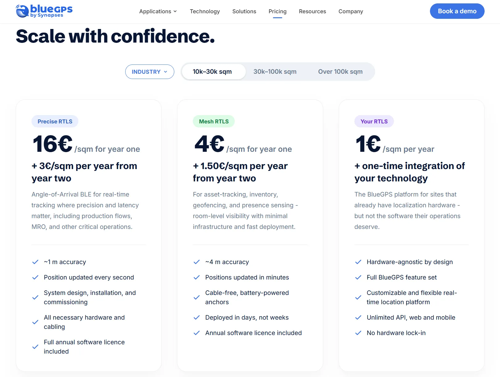
Some vendors simplify this considerably. BlueGPS, for example, prices its software on a single figure based on the area covered, with additional options layered on for specific configurations or integrations a deployment might need. That gives buyers a clear, scalable number to plan around, and it applies whether the deployment uses BLE, UWB or a mix, since the pricing sits at the software layer rather than being tied to one positioning technology. It’s one way to see the difference between paying for a feature-gated stack and paying for access to a full, hardware-agnostic platform.
Because pricing models vary this much between vendors, it’s worth asking directly whether a quote covers the full feature set or whether analytics, integrations and higher update rates are sold as add-ons before comparing any two numbers.
How to compare RTLS software platforms
The most useful starting point isn’t which platform claims the highest accuracy. It’s the operational problem you’re trying to solve, then working backward to the location technology and software architecture that can support it. Software with excellent centimeter-level accuracy is a poor fit if the real need is knowing which building an asset is in.
| Capability | Why it matters | Questions to ask |
|---|---|---|
| Mapping and zones | Converts coordinates into operational spaces | Can maps, floors, layers and zones be configured without vendor involvement? |
| Technology support | Determines deployment flexibility | Can the software consume BLE, UWB, RFID, Wi-Fi or GPS data, and combine more than one? |
| Asset data | Adds business context to raw location | Can metadata come from ERP, MES, CMMS or EAM systems? |
| Rules and workflows | Turns location into action | Can events trigger alerts, API calls or automated processes? |
| History and analytics | Supports process improvement | How long is history stored, and how easily can it be analyzed? |
| Integration | Prevents the platform from becoming another data silo | Are APIs and webhooks documented and supported? |
| Administration and security | Controls access and governance | Are role-based permissions, SSO and audit logging supported? |
| Cost model | Affects total cost of ownership | How are software, infrastructure, integration and support each priced? |
Beyond the table, it’s worth assessing scalability (can it grow from a pilot to a multi-site rollout without a rebuild), user experience, deployment model (cloud, on-premises or hybrid), and the implementation support the vendor provides during rollout.
RTLS software FAQs
What does RTLS stand for? Real-time location system, sometimes written as real-time locating system. It refers to technology that tracks people, assets or equipment, typically indoors or across industrial sites where GPS doesn’t work reliably.
What is an RTLS system? The full set of components needed to track location: tags, positioning technology such as BLE, UWB, RFID, Wi-Fi or GPS, infrastructure like readers and anchors, and software that turns raw position data into usable information.
What is RTLS software? The application layer of an RTLS deployment. It connects tags and infrastructure to maps, zones, asset records, alerts, historical data and business system integrations, turning coordinates into operational information.
How much does RTLS software cost? It depends on deployment size, number of assets and users, number of sites, included modules, integration needs and support model. There’s no single standard price, since these factors vary widely.
How much does an RTLS system cost? Total system cost includes software plus tags, readers, anchors, installation, network changes, integrations, training and support. Accuracy and coverage requirements have a major effect, since higher accuracy usually needs denser infrastructure.
Can RTLS software work with different tracking technologies? Some platforms support multiple technologies, such as BLE, UWB and RFID, normalizing the data into a common model. Others are built around one technology; whether multi-technology support matters depends on the deployment’s needs.
What is a hospital RTLS system? An RTLS system used within a healthcare facility, commonly to locate movable equipment, support staff safety workflows and monitor patient flow, with software connecting location data to clinical and asset records.
Where BlueGPS fits
BlueGPS takes a hardware-agnostic approach to RTLS, built around the idea that the software layer shouldn’t force an organization into a single positioning technology. It supports multiple technologies within one software environment, so a facility that needs UWB accuracy in one area and BLE coverage elsewhere doesn’t end up managing two separate applications. That environment includes the capabilities covered above: mapping and workspace configuration, zone and geofence management, asset and tag management, rules and alerts, historical location data, and integrations with common business systems. BlueGPS also publishes its pricing rather than requiring a sales conversation to get a number, which fits the buyer-first approach this article has tried to take: understand the problem first, then evaluate specific platforms against it.
Organizations weighing up their options can book a demo to see the platform working against their own floor plan before making a decision.